Quick summary: Learn how geo mapping for rubber exporters in Vietnam enables EUDR compliance through GPS polygon mapping, traceability, and accurate supply chain data validation.
The EU Deforestation Regulation (EUDR) effective December 30, 2024 demands that all rubber and rubber-derived products entering the EU market be provably deforestation-free. At the core of this requirement lies precise geolocation: GPS polygon mapping of every plot of land where the commodity was produced. Geo mapping for rubber exporters in Vietnam is becoming a critical capability, enabling accurate data capture, validation, and compliance at scale. This guide walks through each element of that process.
Regulation (EU) 2023/1115 commonly called EUDR entered into force on June 29, 2023, with mandatory compliance dates beginning in late 2024. It targets seven high-deforestation commodities, rubber being one of them, along with cattle, cocoa, coffee, palm oil, soya, and wood.
Operators and traders placing rubber on the EU market must demonstrate three things before a single kilogram crosses the border:
Article 9 of EUDR makes geolocation non-negotiable. For commodities like rubber that come from land, every operator must submit the precise geographic coordinates in the form of GPS polygons of the plot(s) where the commodity was produced. Key data requirements include:
| Requirement | Specification |
|---|---|
| Coordinate type | GPS polygons (lat/long pairs forming a closed boundary) |
| Accuracy standard | Parcel-level, sufficient to verify against satellite forest-cover data |
| Cut-off date | December 31, 2020 (forest cover must be intact at this date) |
| Format requirement | GeoJSON or compatible geospatial format |
| Linked documentation | Due diligence statement referencing coordinates |
| Submission system | EU TRACES / dedicated EUDR IT platform |
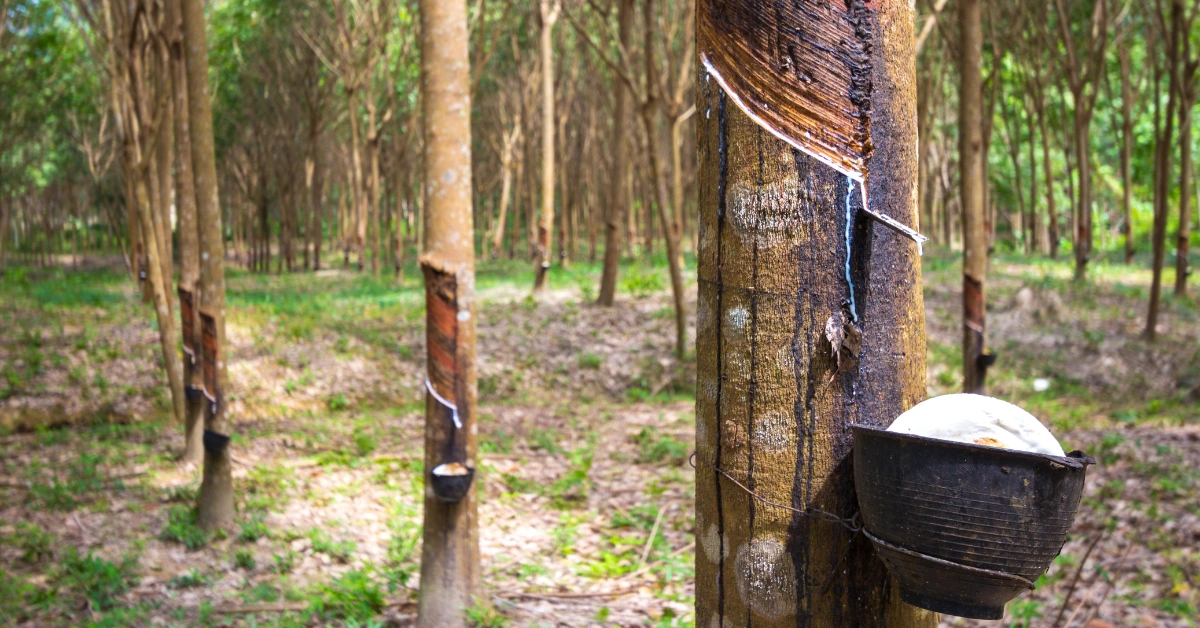
Vietnam is one of the world’s major rubber exporters, with export value reaching about US$3.33 billion in 2025 and volumes at 1.91 million tonnes, though both were lower than 2024 levels. The country also exported around 2 million tons in 2024 and remained among the top five global exporters, supported by a large plantation base of about 910,000–930,000 hectares and annual latex output around 1.3 million tons.
China is Vietnam’s dominant rubber buyer, followed by India, with smaller but important markets in the United States, Germany, and Turkey. In 2024, Vietnam’s rubber export revenue was heavily concentrated in Asian markets, with one report saying 86.8% of export revenue came from Asia in Q1 2025. This makes Vietnam highly exposed to demand swings and price changes in China, which is both its largest outlet and its most important pricing reference.
Vietnam’s rubber sector is strategically important because it links agricultural production, processing, and industrial supply chains, while also serving a growing compliance market for traceable and sustainable materials. For buyers, the key questions are origin verification, plantation legality, and sustainability documentation, especially as global regulations increasingly reward traceable natural rubber. For exporters, the upside is access to premium and regulated markets, but the downside is higher compliance cost and concentration risk from China dependence.
| Indicator | Figure | Context |
|---|---|---|
| Export Value | US$3.33 billion | Total revenue recorded for the 2025 calendar year. |
| Export Volume | 1.91 million tonnes | The physical quantity of rubber shipped internationally in 2025. |
| Production | 1.3 million tonnes | Total domestic output recorded in 2024. |
| Plantation Area | 910,000–930,000 ha | Total land currently under rubber cultivation. |
The EUDR’s GPS polygon requirement is not administrative bureaucracy it is the technical backbone of the entire deforestation-detection system. Without precise boundaries, compliance cannot be verified.
The EU and third-party verifiers use satellite imagery particularly from Copernicus, ESA’s Sentinel programme, and Global Forest Watch to assess forest cover changes at the parcel level. This only works if exact polygon boundaries are known. The verification logic runs as follows:
Earlier commodity-traceability schemes often accepted a single GPS centroid (a point representing the center of a farm). EUDR explicitly requires polygons because:
| Regulatory Note: For plots smaller than 4 hectares, the EUDR technical guidance allows a minimum of 4 coordinate pairs forming a closed polygon. Larger plots must reflect true parcel boundaries. Using a square bounding box is technically non-compliant for irregularly shaped farms. |
Understand EUDR geolocation requirements in detail. Learn how to capture accurate GPS polygons and ensure compliance.
Avoid common GeoJSON errors in EUDR submissions. Learn how to validate and correct your geolocation data.
Vietnam’s rubber supply chain presents structural and logistical challenges that make EUDR compliance significantly harder than for plantation-scale operations in, say, Brazil or Malaysia.
Over 47% of Vietnam’s rubber area is managed by smallholder farmers, many with plots under 3 hectares. There are an estimated 250,000+ such plots nationwide, concentrated in the Central Highlands (Tay Nguyen), Southeast region, and parts of the Northwest. Key challenges include:
The main rubber-growing provinces Binh Phuoc, Dak Lak, Gia Lai, Dong Nai, and Tay Ninh include remote terrain with inconsistent mobile connectivity. Field mapping teams face:
Vietnam’s rubber processing industry relies on a network of small- and medium-sized processing plants that aggregate latex and dry rubber from dozens of collectors who, in turn, source from hundreds of farmers.
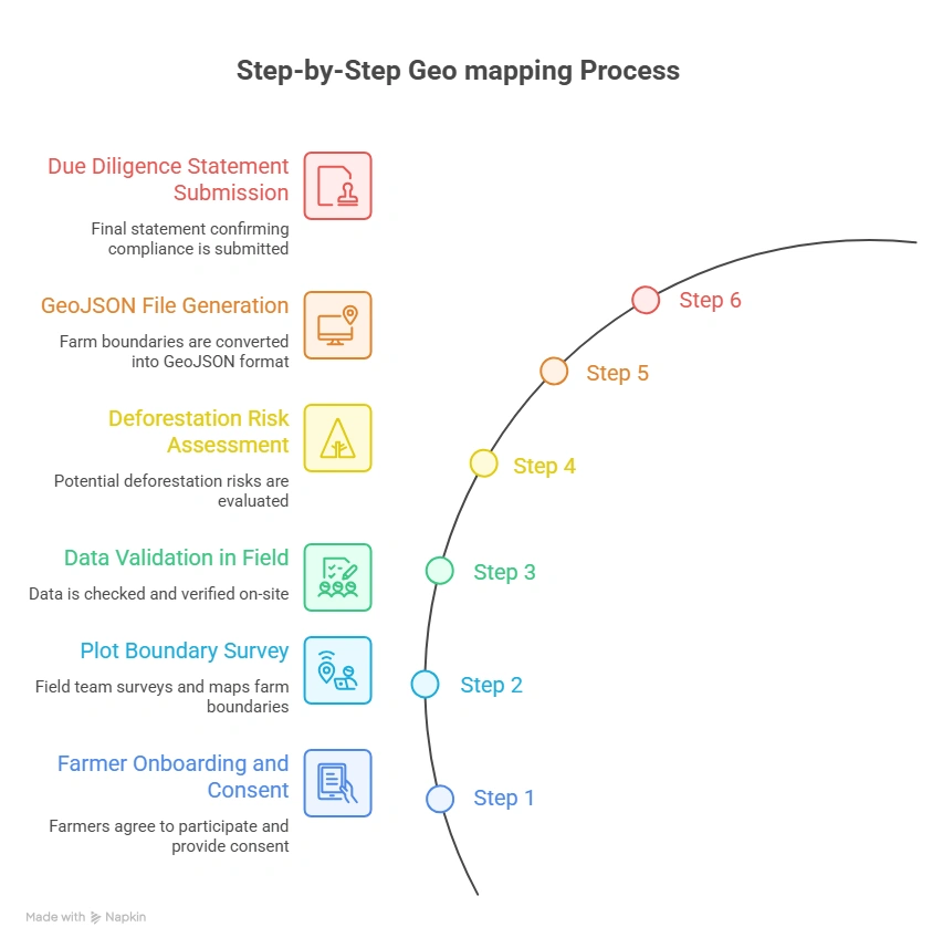
Below is a field-tested geo-mapping workflow designed for Vietnam’s rubber supply chain, balancing regulatory compliance with practical ground-level realities.
Before any mapping begins, exporters must establish a legal and ethical basis for collecting farmer data. This involves:
Field agents typically using GPS-enabled smartphones or dedicated GNSS devices walk the perimeter of each rubber plot to capture polygon coordinates. Best practice protocol:
On-device validation should be performed immediately after capture, before leaving the plot:
Once coordinates are captured, they must be screened against forest-cover databases before submission:
Validated coordinates must be exported in GeoJSON format (RFC 7946 compliant) for submission:
| Specification | Value |
|---|---|
| Geometry type | Polygon (Feature) |
| Coordinate system | WGS 84 (EPSG:4326) mandatory |
| Coordinate order | Longitude first, then Latitude (per GeoJSON spec) |
| Winding order | Exterior ring: counter-clockwise |
| Properties | farmer_id, plot_id, area_ha, crop_type, country, region |
| Encoding | UTF-8 |
| Validation tool | geojsonlint.com, QGIS geometry validator, or Turf.js |
The final step links the GeoJSON polygon data to an official due diligence statement (DDS) submitted through the EU’s TRACES NT or the dedicated EUDR platform:
Geo mapping for Rubber Exporters in Vietnam becomes seamless with TraceX EUDR solutions, enabling accurate GPS polygon capture, real-time validation, and end-to-end compliance management.
Data quality failures at the polygon level are the single most common reason EUDR submissions are flagged for review or rejected. Field teams and data managers should be trained to identify and fix the following errors:
| Error Type | Description | Impact | Fix |
|---|---|---|---|
| Self-Intersection | Polygon boundary crosses itself, creating a ‘bowtie’ shape. Occurs when field agent reverses direction while walking. | Fails GeoJSON validation; geometry engine cannot compute area. | Re-walk boundary; use QGIS Fix Geometries tool. |
| Unclosed Ring | First and last coordinate pair do not match. Polygon ring is not closed. | GeoJSON spec violation; most validators reject outright. | Append first coordinate to end of ring, or use auto-close in KoboToolbox. |
| Wrong CRS | Coordinates recorded in VN-2000 (Vietnam national projection) or UTM instead of WGS 84. | Coordinates displaced by hundreds of meters from true location. | Reproject to EPSG:4326 using QGIS or GeoPandas. |
| Reversed Winding Order | Exterior ring wound clockwise instead of counter-clockwise per RFC 7946. | Some parsers treat interior of polygon as exterior; area inversion. | Reverse coordinate array; QGIS ‘Rewind Polygons’ tool. |
| Coordinate Swap | Latitude and longitude values transposed (lat first, instead of GeoJSON spec’s lon first). | Plot placed in wrong hemisphere or ocean; immediate deforestation false-alarm. | Validate first coordinate: Vietnam lon ≈ 102–109°E; lat ≈ 8–23°N. |
| Spike Artefacts | One or more vertices are outliers caused by GNSS signal bounce under canopy. | Polygon area inflated; boundary bleeds into adjacent plots. | Remove outlier points; apply Douglas-Peucker simplification at 1m tolerance. |
| Duplicate Polygons | Same farm submitted twice with different farmer_id due to aggregator duplication. | Inflated area records; compliance review flags double-counting. | Spatial deduplication using PostGIS ST_Equals or Turf.js booleanEqual. |
| Overly Simplified Polygon | Only 3 or 4 vertices used for complex, irregularly shaped plots. | True boundary not captured; adjacent deforested land may be excluded or included. | Minimum 6–8 vertices for plots with non-linear edges; re-survey if needed. |
For Vietnam’s rubber exporters, EUDR compliance is not a documentation exercise it is a fundamental supply-chain transformation. The GPS polygon requirement sits at the heart of that transformation, providing the verifiable link between a plot of land, its forest-cover history, and the rubber that enters the European market.
The challenges are real: smallholder fragmentation, cadastral gaps, and geospatial data quality are all significant hurdles. But the pathway is clear. Exporters who invest now in robust geomapping infrastructure combining mobile data collection, spatial database management, deforestation risk screening, and compliance platform integration will not only satisfy EUDR requirements, but build a durable competitive advantage in the global market.
The clock is running. Geolocation is the foundation. Build it right.
Explore the tools you need for EUDR compliance. Discover how rubber exporters are using digital solutions for geolocation, traceability, and DDS submission.
Understand EUDR compliance requirements for rubber supply chains. Learn what exporters must do to ensure deforestation-free sourcing.
Learn how rubber exporters in Vietnam can meet EUDR requirements. Explore geolocation, traceability, and compliance workflows tailored to Vietnam.
Geo mapping for rubber exporters in Vietnam involves capturing GPS polygon coordinates of rubber farms to verify origin and ensure compliance with EUDR deforestation-free requirements.
Geo mapping is mandatory under EU Deforestation Regulation as it enables verification that rubber is not sourced from deforested land after December 2020.
Exporters must collect:
Geolocation data is captured using mobile apps, GPS devices, or uploaded GeoJSON/KML files, often supported by field agents or digital traceability platforms.
Key challenges include:
Digital tools help overcome these by enabling automated validation, risk scoring, and traceability at scale.