Quick summary: EUDR Deforestation Risk Assessment for Coffee Supply Chain in Kenya: Learn how to assess deforestation risk, collect geolocation data, mitigate compliance gaps, and prepare Kenya coffee exports for EU enforcement.
A single unmapped farm plot could stop your coffee shipment at EU borders. Under the EU Deforestation Regulation (EUDR), companies placing coffee on the EU market must now prove at the farm level that their products are deforestation-free and legally produced. For exporters and EU buyers sourcing from Kenya, this introduces new compliance pressures. Kenya’s environmentally sensitive highland ecosystems, smallholder-dominated coffee farming, and mixed agroforestry systems make the EUDR Deforestation Risk Assessment for Coffee Supply Chain in Kenya more than a regulatory requirement it is a critical step to maintain uninterrupted EU market access.
Without a structured risk assessment framework, operators risk shipment delays, rejected consignments, compliance penalties, and reputational damage in sustainability-sensitive European markets.
TraceX EUDR Solutions help coffee exporters and EU importers streamline geolocation mapping, satellite-based deforestation screening, supplier risk assessment, and due diligence documentation ensuring your Kenya coffee supply chain meets EUDR requirements with confidence.
The EU Deforestation Regulation (EUDR) requires operators to prove that coffee placed on the EU market is deforestation-free, legally produced, and fully traceable to geolocated plots of land. This shifts responsibility directly onto importers, meaning compliance must be demonstrated before products are sold or exported within the EU.
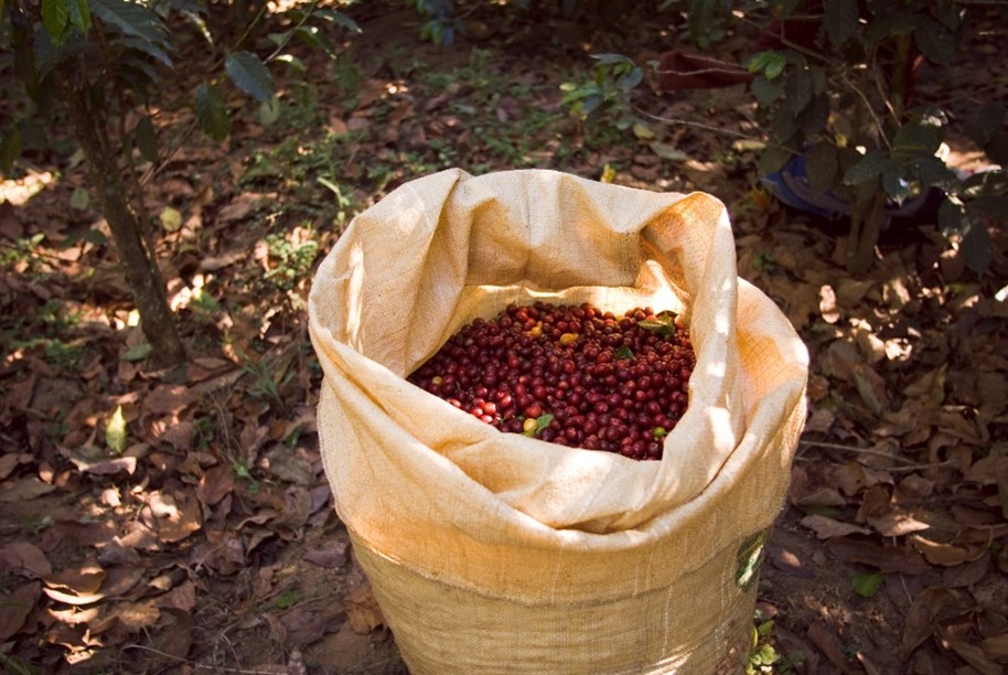
Coffee is explicitly covered under HS code 0901, including green coffee beans, roasted coffee, and certain derived products. Any operator placing these products on the EU market must submit a formal due diligence statement through the EU’s information system. This statement confirms that a structured risk assessment has been conducted and that the risk of deforestation is “negligible.”
A core requirement is geolocation data. Importers must collect precise GPS coordinates (latitude and longitude) for every farm or plot where the coffee was grown.
This data is cross-checked against satellite imagery and deforestation monitoring systems.
The regulation also establishes a strict cut-off date: 31 December 2020. Coffee sourced from land that has experienced deforestation after this date cannot be placed on the EU market, regardless of legality under local laws.
Under EUDR, “deforestation-free” means that the coffee was produced on land that has not experienced deforestation after 31 December 2020.
A forest is generally defined using FAO-aligned criteria, including:
The regulation distinguishes between:
While EUDR focuses primarily on deforestation, degradation of primary forests is also restricted raising scrutiny in forest-rich sourcing regions like Kenya’s highland ecosystems.
For coffee importers, compliance is no longer documentation-based alone it is data-driven, satellite-verified, and plot-specific.
The EU accounts for approximately 30% of global coffee imports, with recent data showing around 48 million bags (EU27, 2024) against global trade volumes of roughly 160 million bags annually making EUDR readiness essential for exporters serving the European market.Are you exporting coffee to the EU? Read our complete guide on EUDR Coffee Compliance for Exporters to understand documentation, geolocation requirements, and shipment readiness steps.Need a structured approach? Learn how to conduct a deforestation risk assessment under EUDR using geolocation mapping and satellite verification.
Kenya faces growing regulatory attention under the EU Deforestation Regulation (EUDR) due to localized forest loss, agricultural expansion, and land-use pressures in key growing regions. While Kenya is globally recognized for tea and horticulture exports, its coffee sector operates in ecologically sensitive highland zones where agriculture and forest ecosystems often intersect. This makes an EUDR Deforestation Risk Assessment for Coffee Supply Chain in Kenya a critical requirement for exporters and EU importers seeking uninterrupted market access.
Historically, Kenya has experienced deforestation driven by agricultural expansion, settlement growth, logging, and fuelwood extraction. Forested regions such as the Central Highlands, Mount Kenya ecosystem, Aberdare Range, and parts of the Rift Valley have seen land-use change over time. Coffee cultivation primarily grown in fertile highland areas can overlap with former forest zones, increasing scrutiny on farm origin and land conversion timelines.
Under the EUDR country benchmarking framework, the European Commission will classify producer nations as low, standard, or high risk based on deforestation history, governance quality, and enforcement capacity. Countries with measurable forest loss and complex land-use patterns may face enhanced due diligence expectations. For operators sourcing from Kenya, this means stronger documentation, traceability, and risk mitigation evidence may be required.
Coffee farming in Kenya is largely smallholder-driven, with most growers cultivating modest plots within cooperative structures. While small-scale farming reduces the likelihood of large industrial forest clearance, it introduces traceability and geolocation challenges under EUDR.
Encroachment risks arise when farms gradually expand toward forest margins without formal boundary documentation. In areas where land tenure includes customary or community-managed systems, precise farm boundary mapping is often unavailable. This makes it difficult to verify whether coffee cultivation began before the EUDR deforestation cut-off date of 31 December 2020.
Kenya retains roughly 7–8% forest cover of its total land area, below the global average, and has faced periodic forest loss linked to agricultural expansion and infrastructure development. According to FAO and Global Forest Watch datasets, Kenya has experienced fluctuating annual tree cover loss, particularly in montane forest ecosystems that also support coffee-growing regions. While Kenya’s overall deforestation rate is lower than several tropical producers, localized forest pressure remains a compliance concern.
For EU importers conducting an EUDR Deforestation Risk Assessment for Coffee Supply Chain in Kenya, these dynamics combined with cooperative aggregation models and fragmented farm data make satellite monitoring and precise geolocation mapping essential tools for demonstrating negligible deforestation risk.
EUDR risk assessment for Kenyan coffee requires farm-level geolocation and verification against satellite deforestation datasets after 31 December 2020. Kenya benefits from relatively structured agricultural governance and strong cooperative systems, but fragmented smallholder production and mixed cropping still require systematic risk screening.
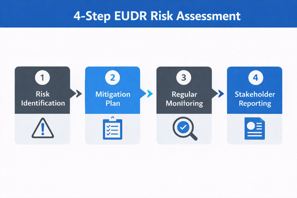
Step 1
The first step in an EUDR Deforestation Risk Assessment for Coffee Supply Chain in Kenya is gathering accurate geolocation data for every supplying farm.
Because Kenyan coffee is commonly grown in mixed farming systems alongside tea, maize, bananas, or agroforestry trees mapping may require field surveys, mobile GIS tools, or cooperative-led mapping initiatives.
Without accurate coordinates, deforestation verification cannot proceed.
Step 2
Once geolocation data is captured, operators must determine whether mapped farms overlap with deforestation events occurring after the EUDR cut-off date.
This involves:
If satellite analysis shows coffee cultivation on land cleared after the cut-off date, the product cannot qualify as deforestation-free under EUDR.
Step 3
EUDR also requires verification that production complies with national laws.
For Kenyan coffee supply chains, this includes reviewing:
Kenya has relatively established land governance systems, but documentation gaps can occur in community-managed or inherited lands, requiring careful validation.
Step 4
Operators must assess how coffee moves from farm to export.
Risk factors include:
More complex supply chains make it harder to confirm farm-level compliance and assign a negligible risk status.
Several digital solutions support EUDR deforestation risk assessment for Kenyan coffee supply chains:
By combining geolocation mapping, satellite verification, legality checks, and supply chain risk analysis, importers can determine whether Kenyan coffee presents negligible deforestation risk or requires further mitigation.
Kenya Coffee Sector Snapshot
Kenya’s coffee sector is smaller than its tea industry but remains globally recognized for specialty Arabica production.
This smallholder, cooperative-driven structure strengthens quality but increases traceability complexity under EUDR.
Several structural and operational factors can increase EUDR compliance risk in Kenya’s coffee supply chain. Although Kenya is globally known for high-quality Arabica coffee and has stronger cooperative systems than many producing countries, similar supply chain characteristics — such as smallholder dominance, mixed farming systems, and complex land tenure — create challenges when conducting an EUDR Deforestation Risk Assessment for Coffee Supply Chain in Kenya.
One of the primary risk indicators is incomplete geolocation coverage across supplying farms. Many smallholder coffee producers lack precise GPS coordinates or digitally mapped farm boundaries. Without accurate plot-level mapping, importers cannot verify whether land experienced deforestation after the EUDR cut-off date of 31 December 2020, making compliance validation difficult.
Land ownership in Kenya is governed by a mix of private titles, community land systems, cooperative holdings, and inherited family plots. While legal frameworks are relatively structured, documentation gaps and informal inheritance practices can complicate legality verification under EUDR requirements.
Kenyan coffee is largely marketed through cooperative societies and washing stations that aggregate cherries from numerous smallholder farmers. Once beans are pooled, tracing coffee back to individual farm plots becomes more complex. This increases the risk of mixed lots containing coffee from farms with incomplete geolocation or unclear land-use history.
Coffee in Kenya is often cultivated within diversified farming systems alongside tea, maize, bananas, macadamia, and shade trees. While agroforestry supports sustainability and biodiversity, mixed land use can complicate farm boundary identification and satellite verification when crop zones are not clearly digitized.
Weak digital record systems such as missing farmer identifiers, inconsistent farm size declarations, or outdated cooperative records can undermine the reliability of due diligence statements required under EUDR.
When sourcing coffee from Kenya, operators should monitor warning signs such as:
Identifying these risk indicators early allows importers and exporters to implement mitigation measures such as geolocation mapping, cooperative-level traceability upgrades, supplier verification, and satellite monitoring before submitting EUDR due diligence statements.
Kenya Coffee Sector Snapshot
TraceX EUDR Solutions are designed to help coffee exporters, cooperatives, and EU importers meet EUDR requirements through automated, data-driven compliance tools.
The platform supports end-to-end EUDR deforestation risk assessment by:
For Kenya coffee supply chains, TraceX helps address common challenges such as cooperative-based aggregation, fragmented smallholder sourcing, incomplete farm mapping, and limited digital traceability systems.
If deforestation risk is assessed as more than negligible, operators must implement effective mitigation measures before placing Kenyan coffee on the EU market. Under EUDR, identifying risk alone is insufficient importers and exporters must demonstrate concrete actions that reduce the likelihood of deforestation or legality violations.
Independent geospatial analysis can confirm whether supplying farms experienced forest cover loss after the 31 December 2020 cut-off date. Satellite verification strengthens risk assessment credibility and provides objective evidence during inspections.
Many smallholder farms lack clearly defined digital boundaries. GPS mapping and polygon digitization allow operators to verify land-use history and ensure coffee production areas do not overlap with recently deforested land. Digitized farms also improve traceability across cooperative supply chains.
Contracts with farmers, cooperatives, and intermediaries can formalize compliance expectations by:
In higher-risk sourcing zones especially near forest ecosystems such as Mount Kenya and the Aberdare Range on-site inspections may be required. Field audits verify farm boundaries, validate documentation, and confirm sustainable land-use practices.
Certification schemes such as Rainforest Alliance and Fairtrade can support mitigation by promoting sustainable farming practices, environmental safeguards, and improved traceability.
However, certification alone does not automatically guarantee EUDR compliance.
EUDR requires:
These requirements often exceed traditional certification scope. Certification should therefore be treated as a supporting mitigation layer not a substitute for a full EUDR deforestation risk assessment.
By combining satellite monitoring, digital farm mapping, supplier agreements, cooperative traceability upgrades, and independent verification, operators sourcing from Kenya can reduce supply chain risk to a defensible “negligible risk” level before submitting EUDR due diligence statements.
From 2027 onward, EU customs authorities can block non-compliant coffee shipments. Once enforcement begins, due diligence statements will be mandatory before products can be placed on or exported from the EU market. For importers sourcing from Kenya, preparation must begin well before the deadline to avoid shipment disruption and financial loss.
The first step is to conduct full supply chain mapping now. Importers must identify every actor in the chain — from farm level to cooperative, washing station, exporter, and trader — and ensure traceability down to individual plots. This includes documenting farm geolocations, cooperative collection points, processing facilities, storage hubs, and consolidation centers. Without end-to-end visibility, risk assessment cannot be performed reliably.
Next, operators should segment suppliers by risk level. Not all sourcing partners carry the same exposure. Factors such as proximity to forest ecosystems, documentation quality, cooperative governance strength, farm size, and digital traceability maturity should be used to classify suppliers as low, medium, or high risk. Higher-risk suppliers may require enhanced satellite verification, field audits, or additional mitigation measures before sourcing continues.
Importers should also pilot geolocation collection programs immediately. Waiting until enforcement begins will create operational bottlenecks. Pilot programs allow companies to test GPS data capture, polygon boundary mapping, satellite overlay validation, and traceability data management systems. Early implementation helps identify mapping gaps and workflow challenges before they impact shipments.
Finally, companies must establish internal compliance governance. Responsibility for EUDR readiness should be clearly assigned across procurement, sustainability, legal, compliance, and IT teams. Internal policies should define:
By embedding compliance into procurement and governance structures now, EU importers can move from reactive documentation gathering to structured, defensible EUDR readiness before enforcement begins.
Kenya-origin coffee holds strong positioning in EU specialty and premium markets, but it also requires structured, data-driven risk screening under EUDR. Given Kenya’s ecologically sensitive highland regions, smallholder-dominated production systems, cooperative aggregation models, and mixed agroforestry practices, importers cannot rely solely on supplier declarations or basic paperwork. A defensible EUDR Deforestation Risk Assessment for Coffee Supply Chain in Kenya must be built on verified geolocation data, satellite-based deforestation screening, and well-documented legality verification.
Geolocation traceability has become the backbone of EUDR compliance. Without precise GPS coordinates or polygon mapping for every supplying farm, deforestation screening cannot be completed and due diligence statements cannot be confidently submitted. Plot-level transparency is no longer just best practice — it is now a regulatory obligation.
With enforcement timelines approaching, proactive mitigation is essential. Importers that begin mapping supply chains, digitizing farm boundaries, strengthening cooperative and supplier agreements, and implementing satellite monitoring today will reduce disruption risks tomorrow. Those that delay may face shipment holds, financial penalties, and reputational damage in sustainability-sensitive markets.
In the EUDR era, early preparation remains the strongest safeguard for maintaining uninterrupted access to EU markets.Need clarity on geolocation, satellite checks, and risk scoring? Explore our in-depth EUDR risk assessment framework.Is your sourcing country classified as low, standard, or high risk? Learn how EUDR country benchmarking works.Missing farm-level data? Discover how to conduct a structured EUDR supplier assessment.
No. Kenya is not automatically classified as “high risk.” However, sourcing from ecologically sensitive highland regions and areas near forest ecosystems can increase scrutiny. Final risk classification depends on EU benchmarking and farm-level deforestation assessments.
Yes. Where formal land titles are limited, operators can rely on recognized land-use documentation, cooperative records, community agreements, and satellite verification to demonstrate legality and negligible deforestation risk.
Yes, but structured traceability is essential. Supply chains must capture farm-level geolocation data, maintain lot-level segregation, and implement reliable digital recordkeeping to prevent mixed-origin compliance risks.
No. Certification supports sustainable production and traceability practices but does not replace EUDR obligations. Operators must still provide plot-level geolocation data and verify that no deforestation occurred after the 2020 cut-off date.
Shipments may be delayed, blocked, or rejected. Authorities can request additional documentation, conduct compliance inspections, or impose penalties. Conducting a proper deforestation risk assessment before export helps prevent costly disruptions.