Quick summary: Supply chain mapping for EUDR compliance: learn how to trace materials from forest to finished product, capture geolocation data, assess deforestation risk, and build a transparent, audit-ready supply chain for seamless EU market access.
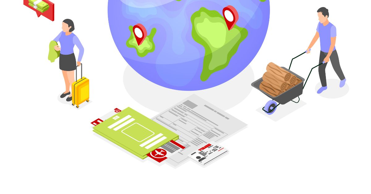
Supply chain mapping for EUDR compliance means identifying and documenting every supplier, processor, and plot of land in your commodity supply chain from farm origin to finished product and linking that data to geolocation coordinates, deforestation risk assessments, and Due Diligence Statements (DDS) submitted via EU TRACES. Required for cocoa, coffee, soy, palm oil, rubber, timber, and cattle derivatives by December 30, 2026 (large/medium operators).
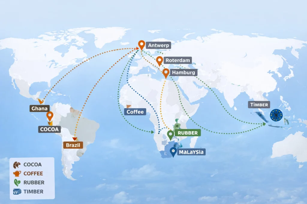
If you source cocoa from West Africa, rubber from Southeast Asia, or timber from the Amazon and any of it enters the EU market supply chain mapping is now a legal obligation, not a best practice.
The EU Deforestation Regulation (EUDR, Regulation EU 2023/1115) requires businesses to prove their products are deforestation-free and legally produced. That proof starts with knowing, at plot level, exactly where every batch originated.
Yet according to recent industry analysis, only 30% of upstream actors and 12% of downstream players have systems in place to trace deforestation. If your organization is in that majority, this guide will show you exactly what to build and how TraceX Solutions makes it operationally achievable.
| 4% Minimum fine of EU annual turnover for non-compliance | 30% Only 30% of upstream actors have traceability systems in place | Dec 2026 Compliance deadline for large & medium operators |
The EU Deforestation Regulation (EUDR) targets seven high-risk commodities whose production has historically driven tropical deforestation:
Compliance applies to any business placing these products on the EU market, or exporting them from it, regardless of where they are headquartered.
| Company Type | Compliance Deadline |
|---|---|
| Large & medium operators | December 30, 2026 |
| Micro & small operators | June 30, 2027 |
| Non-EU exporters to EU | December 30, 2026 (same as operators) |
| Downstream traders (non-first placer) | Simplified declaration required |
| Regulatory Context The EUDR requires a Due Diligence Statement (DDS) for every product batch, submitted via the EU TRACES system. The DDS must include: GPS-verified geolocation of all plots, supplier identity and documentation, deforestation risk assessment, and proof of legal production. Incomplete or inaccurate geolocation data is one of the top reasons DDS submissions are rejected. |
Manual tracking won’t meet EUDR standards. Discover how digital traceability ensures compliance and real-time supply chain visibility—read our blog.
Do you have polygon-level geolocation for your sourcing? Understand EUDR’s strict geolocation requirements—read the full blog.
Most compliance heads understand the what they struggle with the how. Here are the real-world obstacles your peers are dealing with:
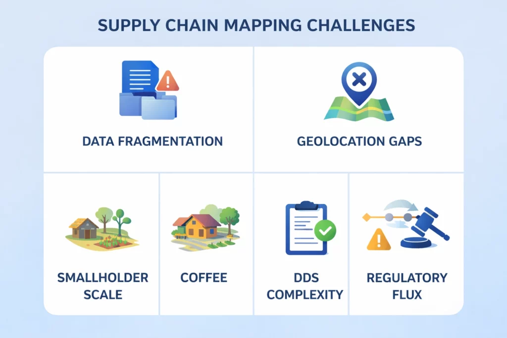
In a typical agri-commodity supply chain, data lives across spreadsheets, WhatsApp messages, PDFs, and siloed ERP systems. Aggregating this into a single compliant record is not a data problem it is a structural problem.
Real example: A mid-sized European coffee importer discovered their Tier-3 suppliers in Ethiopia were using hand-drawn farm boundaries from land surveys taken in 2011. Under EUDR, those boundaries must be converted to GeoJSON polygons referenced against post-2020 satellite data a project that took four months of field team work without digital tooling.
Discover how a leading tire company achieved EUDR compliance through large-scale polygon mapping. Read the full case study to see how traceability at scale can transform your supply chain.
EUDR mandates plot-level precision. A single GPS point may suffice for very small plots, but polygon boundaries (mapped land perimeters) are required for meaningful deforestation checks. In remote sourcing regions smallholder farms in Indonesia, subsistence plots in Cameroon traditional GPS tools and land registries are unreliable or absent.
Many commodity supply chains include tens of thousands of smallholder farmers. Digitally onboarding each with GPS plot data, KYC documents, and legal declarations is operationally intensive. Low digital literacy and language barriers compound the challenge.
See how integrated KYC validation transformed farmer onboarding and strengthened supply chain compliance. Read the full case study.
Creating a Due Diligence Statement manually for each consignment cross-referencing GeoJSON files, supplier data, volume declarations, risk assessments, and EORI numbers is error-prone and does not scale. Manual workflows create compliance gaps and audit risk.
The EUDR country risk benchmarking system (low / standard / high risk) changes as the EU updates its country classifications. Organizations using static compliance frameworks face constant re-work when country classifications shift.
Supply chain mapping under EUDR is not a one-time exercise. It is a living data system with four core functions:
You must be able to trace every product from the plot of land where it was grown or harvested, through every processing step, to the point it enters the EU market. Each handover between suppliers, processors, traders, and exporters must be documented.
Every farm or production plot in your supply chain must be mapped with either a GPS point (for small plots) or polygon boundaries. These coordinates are cross-verified against satellite imagery including JRC and Hansen datasets to confirm the land was not deforested after December 31, 2020.

Mapping is the input to risk assessment. For each plot and supplier, you must evaluate:
Every product batch placed on the EU market requires a DDS filed via EU TRACES. The DDS must reference the geolocation data, supplier records, risk assessment outcomes, and volume declarations. Downstream traders reference the DDS reference number rather than filing independently but they are still responsible for retaining it.
Identify every product line that contains EUDR-regulated commodities. Map your current Tier-1 suppliers and extend upstream to identify Tier-2 and Tier-3 sources. This scoping exercise determines the scale of your data challenge.
Who owns this: Procurement and compliance teams jointly.
Replace paper-based supplier questionnaires with structured digital onboarding. Capture for each supplier:
Practical tip: Use mobile-first onboarding tools that work offline in low-connectivity regions. Field agents can capture polygon data with a smartphone camera and GPS, with data syncing to the cloud when connectivity is restored.
Raw GPS data from suppliers is not sufficient. Geolocation must be:
| What happens when geolocation is wrong? Incorrect geolocation data is one of the top reasons DDS submissions are rejected by EU TRACES. A single plot with unverifiable coordinates can halt an entire consignment at customs causing shipment delays, contractual penalties, and buyer trust issues. Automated geometry validation before submission prevents this entirely. |
Once geolocation is validated, run risk scoring at the plot level. Risk factors include:
Plots flagged as high-risk require additional mitigation: independent audits, supplementary documentation, or supplier replacement.
For each product batch, compile the DDS with:
Submit via EU TRACES. Retain all documentation for a minimum of five years for audit readiness.
Compliance is not a one-time milestone. Supply chains change new suppliers are added, geopolitical situations shift country risk classifications, and new deforestation alerts are issued. Set up real-time monitoring to receive alerts when:

Industry: Automotive / Natural Rubber
Challenge: A leading tyre manufacturer sourced natural rubber from across Southeast Asia through a four-tier supply chain. Smallholder farmers who collectively supplied 60% of raw material volume had no digital records.
Approach: Field teams equipped with mobile GPS mapping apps onboarded 12,000+ smallholder plots across three sourcing countries over eight months. Polygon data was validated against deforestation satellite imagery and integrated into an automated DDS workflow.
Outcome: Full GeoJSON mapping coverage achieved. DDS submission automated per consignment. Deforestation-free certification secured for EU market access. Audit time reduced from weeks to hours.
Industry: Coffee / Ethiopia
Challenge: A cooperative aggregating coffee from 8,000 smallholder farmers in Ethiopia needed to provide GPS plot data and legal production evidence for every EU-bound batch. Farmers had no smartphones. Land tenure records were informal. Internet connectivity was sporadic.
Approach: Offline-capable mobile onboarding was deployed with cooperative field agents capturing data on behalf of farmers. AI document parsing extracted land tenure details from scanned physical records. Data synced to the cloud upon connectivity.
Outcome: 8,000 farmers onboarded over 90 days. 97% geolocation validation pass rate on first submission. EU buyer contracts renewed with a 12% margin premium attributed to verified deforestation-free status.
Industry: Cocoa / West Africa
Challenge: A large European cocoa trader sourced from Ghana, Ivory Coast, and Nigeria simultaneously. Each shipment aggregated cocoa from dozens of farms. Maintaining the connection between specific batch volumes and plot-level geolocation across borders and through multiple processors was operationally impossible manually.
Approach: Batch-level traceability linked procurement events to specific plot records. Each export consignment automatically generated a composite DDS referencing all contributing plots. The system flagged any batch containing unvalidated plots before shipment was authorized.
Outcome: Zero shipment rejections at EU customs in the first six months of EUDR enforcement. Manual DDS preparation time reduced by approximately 70%. Buyer audit requests fulfilled in under one hour.
Manual supply chain mapping cannot scale to EUDR requirements. These are the core technology components that leading compliance programs use:
| Technology | What It Enables |
|---|---|
| Satellite Monitoring | Deforestation detection and land-use change verification for every sourced plot |
| Blockchain Traceability | Tamper-proof, immutable chain-of-custody from farm to port auditable by regulators |
| Mobile GPS Mapping (Offline) | Field-level polygon capture in remote or low-connectivity sourcing regions |
| AI Risk Scoring | Automated classification of plots as low / standard / high deforestation risk |
| DDS Automation & TRACES Integration | One-click DDS generation with auto-populated GeoJSON, supplier data, and EORI submission |
| ERP / Procurement Integration | Procurement events automatically trigger traceability workflows — no manual data re-entry |
| Real-Time Alert System | Instant notification when a plot is flagged in new deforestation data or risk classification changes |
EUDR penalties are structured to eliminate any economic incentive for non-compliance:
| Penalty Example A company with EUR 500 million in EU-market revenue that fails to demonstrate deforestation-free sourcing could face a minimum fine of EUR 20 million plus confiscation of product revenue and potential market access suspension. This is before accounting for shipment delays, contractual liabilities, and legal costs. |
| 4% | Minimum EUDR penalty as a percentage of EU annual turnover (Article 25, Regulation EU 2023/1115). Increases with repeat violations. |
Use this checklist to assess your organization’s current readiness:
| Readiness Requirement | Status Check |
|---|---|
| All in-scope commodities identified and documented | Have you confirmed all product lines containing EUDR commodities? |
| Tier-1 suppliers onboarded with GPS plot data | Do you have polygon or point coordinates for every Tier-1 source? |
| Tier-2 / Tier-3 suppliers mapped | Have you traced upstream beyond direct suppliers? |
| Geolocation validated against satellite deforestation data | Are coordinates cross-referenced with JRC / Hansen datasets? |
| Risk assessment completed for all sourcing plots | Are plots classified by deforestation risk level? |
| DDS workflow configured for TRACES submission | Can DDS be generated automatically per consignment? |
| 5-year record retention system in place | Is all documentation stored securely and audit-ready? |
| Continuous monitoring alerts activated | Are you notified in real time of deforestation events or risk reclassifications? |
TraceX EUDR Solutions was built specifically for agri-food and forestry supply chains operating under regulatory traceability requirements. Here is how the platform maps to each EUDR challenge:
Compliance deadlines are approaching and manual processes won’t scale.
Book a Live Demo & See How to Automate EUDR Compliance
Organizations that treat EUDR supply chain mapping as a compliance cost will spend the next 18 months firefighting. Organizations that build it as a strategic data asset will enter a position of competitive advantage that is very difficult to replicate.
Buyers in the EU market are increasingly awarding longer contracts and premium margins to suppliers with verified, audit-ready compliance documentation. Early movers are already seeing this dynamic play out.
The mapping challenge is real but it is solvable. With the right technology, field strategy, and data architecture, EUDR supply chain mapping becomes a scalable operational capability rather than a manual compliance burden.
Not sure what EUDR requires from your business? Read our detailed guide to understand key obligations and stay compliant.
Are there gaps in your EUDR readiness? Discover how to identify and close compliance gaps—read our expert guide.
Your compliance is only as strong as your suppliers. Learn how to assess supplier risk and data quality under EUDR.
Use a mobile-first, offline-capable onboarding platform. Assign field agents equipped with GPS-capable smartphones to capture polygon boundaries and land documents on behalf of farmers. AI-powered document parsers can extract data from physical records. Once collected, validate geometry accuracy and cross-reference against satellite deforestation datasets before generating DDS submissions.
Incorrect or incomplete geolocation is one of the leading reasons DDS submissions fail EU TRACES validation. If flagged, the consignment may be held at the border pending additional evidence. Automated geometry validation before submission — checking for polygon accuracy, plot size plausibility, and deforestation dataset cross-referencing — prevents this from reaching the submission stage.
Not necessarily from scratch — but your mapping must be kept current. New suppliers require onboarding. Existing plots must be re-checked against updated deforestation alerts. Country risk reclassifications by the EU may require additional documentation for previously approved sourcing regions. Continuous monitoring with real-time alert systems replaces the need for annual re-mapping exercises.